Monday, March 8, 2010

March 7 Manzanita, Oregon

Leaving California we continued north along the Oregon coast. The southern portions of the Oregon coast consist of high volcanic cliffs with numerous sea stacks off-shore. Further north, the coastline changes to long,broad sandy beaches and grassy dunes.

For the past few days, we have been camped at Nehalem Bay state park, a park we discovered on our first visit to Oregon and have been looking forward to returning to. The weather is chilly with strong winds, rain and even some sleet! But, we are enjoying it in spite of the weather. Terra gets us out for long walks and keeps us smiling with her antics.


Top of the mountain trail at Harris Beach


High waves crashing on the Oregon coast


Sea stacks at Harris Beach at dusk


How many fingers?? Another Oregon beach


Dunes at Nehalem Bay


Bob and Terra at Nehalem Bay


Windy day on an Oregon beach, Manzanita

Friday, February 26, 2010

February 26 North California Coast

The last week has taken us across the Mojave Desert,through Monument Valley and the Grand Canyon in Arizona to southern California, along the coast through San Francisco, and northward on the coastal highway (Number 1}. The coast of California is enormously variable from lush green hills in the south to rugged coastline with steep cliffs,and breathtaking views. We will continue north along the coast and into Oregon in the next few days. Weather has also been variable,but mostly cool and rainy along the coast. Terra has enjoyed every minute....even the weather.


Monument Valley AZ


A road not taken.......


Mexican Hat near Mexican Hat AZ. The hat is over 30' wide


View of Grand Canyon from the Watchtower


Wall paintings in the Watchtower at the Grand Canyon


Grand Canyon AZ


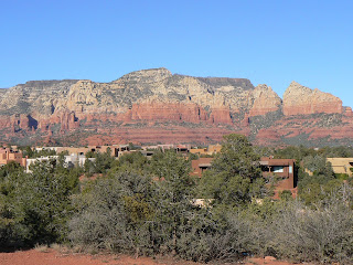
Sandstone cliffs overlooking the beautiful city of Sedona, Arizona


A gift shop called "The House of Joy", formerly a brothel in the old mining town of Jerome.


Cholla cactus in bloom in Joshua Tree NM


Weathered granites in Joshua Tree National Monument AZ


Pumpers in Lost Hills producing field. Several hundred, no problem with spacing requirments here!


Hearst Castle from a distance. We didn't do the tour.


Elephant seals, mostly pups. The large ones are males. Most of the females have gone north to the Aleutiens. There are hundreds on the beaches.


Looking north from Los Padres campsite


Sunset over the Pacific from our campsite at Los Padres.


The Golden Gate Bridge is not "golden". Going through San Fransisco February 24.


View of coastal beach from Reye's Point Lighthouse. Reye's Point is west of the San Andreas Fault and is composed of 100myrs old granite that has moved 270 miles north since formation.


Reye's Point National Monument


Coastal Highway Central California

Monday, February 15, 2010

February 15 Bluff, Utah


El Morro was a stopping point for Spanish explorers heading north from Mexico around 1500. The pond at the front of the picture was a rare source of water along what came to be called "the ancient way".


One of many Spanish inscriptions at El Morro


El Morro National Monument, New Mexico. There are inscriptiona on the cliff walls from as early as 1500


Ancient Way Cafe and RV Park near El Morro NM, elevation 7200 ft. The temperature dropped to -10 on Feb 10 and all our pipes froze. Much to our surprise, by noon the next day all was well with no damage to the plumbing!


Back to a lower elevation and warmer temperatures in the Petrified
Forest near Holbrook AZ.


Petrified forest, a total silicification of wood over millions of years near Holbrook AZ


Meteor Crater impacted 50,000 years ago near Winslow AZ. Finest example in the world. Crater almost 1 mile in diameter, and 700 feet deep.


Rug room at the Hubbell Trading Post


Navajo weaver at Hubbell Trading Post near Chinle AZ


Canyon de Chelly cut into sandstones of the same name,Permian age. Valley farmed by Anasazi for several 100 years until abandoned circa 1250 BCE.


Ruins of an Anasazi village built into the canyon sometime before 1200 BCE


Canyon de Chelly from the north rim


The Navajo grow corn, peaches and other crops in the valleys of Canyon de Chelly.


Since our last blog, we have travelled from El Morro in New Mexico to several interesting spots in northeastern Arizona including the Petrified Forest and Painted Desert, the Meteor Crater and Canyon de Chelly. Today we drove along the north rim of Canyon de Chelly and then north to Bluff,Utah where we are camped tonight. Tomorrow we head back into Arizona through Monument Valley.

Wednesday, February 10, 2010

February 9 Near Albuqurque


A few of the several thousand Sandhill cranes at Bosque del Apache Wildlife Refuge near Socorro NM


One of 21,000 petroglyphs at Petroglyph National Monument (Bighorn sheep)


View from campsite at Valley of Fire


Pahhoehoe (ropy) lava at Valley of Fire


Suset at Valley of Fire New Mexico

We intended to head west through the mountains along highway 60 this morning but were warned of a cold front moving in so we changed our plans and will go only as far as Bluewater State Park east of Gallup, NM. We'll probably stay there until the front moves through and then go back into Arizona.

Monday, February 8, 2010

February 8 Alamogordo New Mexico


Bob at White Sands


Sacrmento Mountains from Oliver Lee SP


I'll come when I'm good and ready!


Marilyn and Terra playing ball


Beautiful white gypsum dunes. There are 275 square miles of them.


Dead cottonwood in the dunes


Sunset at Oliver Lee State Park

We spent the last three days at Oliver Lee State Park near Alamogordo. It has a great campground and is close to White Sands National Monument. That may be the high light of the trip! The pictures tell the story.